With all the stormy weather we've had in the last week it's been a bit difficult to get a decent impression of the Bay of Islands despite having been to Paihia, Matauri Bay (the final resting place of the Greenpeace flagship, "Rainbow Warrior") and Opito Bay - all these places are very picturesque in their own right but not so nice in the torrential rain!
Taking advantage of the beautiful Easter weather, we drove 30km north of Kerikeri to Whangaroa Harbour to get away from the tourist traps so we could hike up St Paul's Rock, as recommended by one of the visitor's guides I read.
Whangaroa is like many of the other townships in the Bay of Islands, in that there isn't much to these places but the surrounding scenery is pretty stunning. At the bottom of the harbour the dome (or volcanic plug) of St Paul's Rock dominates Whangaroa, but it did make me wonder "how on earth do you get to the top?"...
 |
| The marina at Whangaroa is New Zealand's most northerly marina |
 |
| The volcanic plug of St Paul's Rock rises 213m above Whangaroa |
The walk to the top starts off at Old Hospital Road, however, you have to drive up quite a steep single track road, which has limited turning opportunities and only a couple of places to park vehicles at the reserve, otherwise it's another 1km walk from the bottom.
From the bottom of the stile, the walk to the top is roughly 20 - 25 minutes, one-way, over some fairly steep terrain, however, there were some chains running through the middle of the rock which we had to use to pull ourselves to the top - explaining how it was possible to get onto the dome!
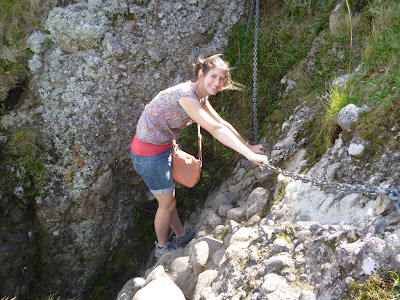 |
| The chains make the final stretch of the walk look more dramatic than it is! |
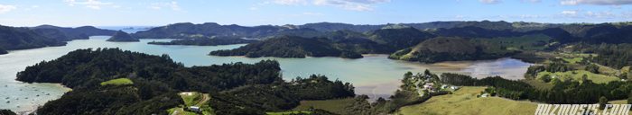
Despite the brief momentary feeling of vertigo, the views from the top were absolutely knockout. Across the harbour you could see where the coastal waters changed from a sparkling blue to a brilliant turquoise. The harbour is characterised by rocky bluffs and the formations that dominate the scenery are remnants of ancient volcanoes that erupted about 20 million years ago.
 |
| It's a fine line between success and failure! |


No comments:
Post a Comment