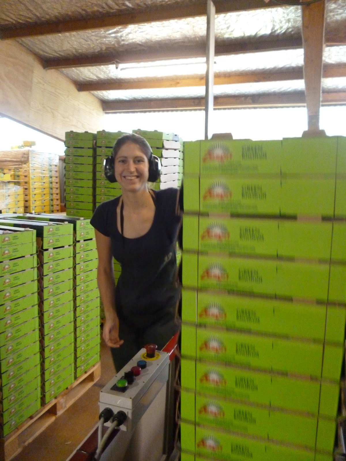
For the last 8 and ½ weeks we've been working in a kiwifruit packhouse in Kerikeri, hence why the posts have been a bit few and far between. It has been a good way to replenish our funds quickly but we've also had to work some pretty long hours doing up to 70 hours a week during the peak of the season. But at the least the work is consistent unlike what can be said about
fruit picking...
 |
| To the left are the green kiwifruits and to the right the gold ones! |
In a nutshell, our main role was to make the boxes that the kiwifruits were packed into, which was as boring and repetitive as it sounds!
 |
| Our employers the past two months, LD Packers in Kerikeri |
 |
| Boxes, boxes everywhere! |
 |
| Lizzie stacking trays on the "IT machine" |
 |
| Me stacking on the "ML machine" |
 |
| It's a serious business running these machines! |
 |
| Lizzie loading card onto the ML machine |
Often the hours were long and arduous, the packhouse was noisy and dusty, and more often than not we'd finish the day feeling like shit with lots of aches, pains and paper cuts, but at least we came through the season with a great bunch of friends we made along the way, despite being let down by some others... It was an experience that I'll never forget but equally hope to never repeat unless I can help it! We even got some brief thanks at the end of the season party for making sure the packhouse was well supplied with boxes and that the packing lines never had to be stopped once because of our efforts! I think the only thing I'll miss about the working in the packhouse is the smell of the limes when the citrus fruits were being packed.
As a way of rewarding ourselves for all the hard work, as well as having spent more time in the Far North than we spent in the whole of New Zealand on our last trip, we decided to go to Cape Rēinga, which is the very northern tip of mainland New Zealand, and for anyone living in the UK this is the equivalent of visiting John o'Groats in Scotland.
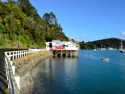
Making our way along State Highway 10 towards Doubtless Bay, we stopped off at a small township called Mangōnui (meaning "big shark") where there's a sheltered harbour. In the middle of the historical waterfront there's a "world famous" fish and chip shop perched on stilts over the water, however, we didn't get anything to eat as it would have been a pretty unusual breakfast.....
 |
| I've got a feeling this "world famous" chip shop never made it out of NZ! |
 |
| Time stands still in Mangōnui |
It was a pretty long drive up along the Aupōuri Peninsula (reaching 108km) passing through some notable places, such as the picturesque Cooper's Beach and Awanui where a giant kauri tree staircase is the centre piece for the "Ancient Kauri Kingdom" gift shop and gallery. Along the final 19km stretch from Waitiki Landing towards the Cape, there were some amazing changes in scenery as the headland steeply rises. We initially read in a couple of guidebooks that this section was unsealed, but to our delight this wasn't the case as the road had been fully completed in April 2010 bringing an end a 75-year nationwide project to seal the road. The drive along State Highway 1F was surprisingly quiet, but this was partly down to us beating the coach-loads of tourists!
After 198km of driving we finally arrived at the most northern part of New Zealand. As expected it was really windy and rugged along the coast, as this the point where the Tasman Sea (to the west) separates from the Pacific Ocean! For the Māori, this is where the male sea, Te Moana Tāpokopoko a Tāwhaki, meets the female sea, Te Tai o Whitireia. The whirlpools where the currents clash represent the coming together of male and female - and the creation of life.
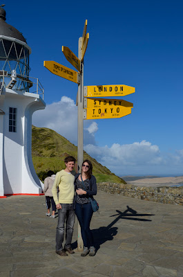 |
| The obligatory tourist shot! |
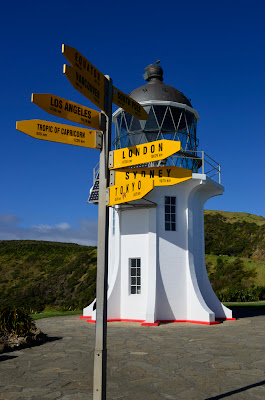 |
| The iconic signpost with the lighthouse |
Oddly enough there's a postbox at the Cape, which holds the claim to be New Zealand's northernmost postbox. Apparently, if you send some mail from this box it is franked with a unique Cape Rēinga stamp - so we took the opportunity to send some postcards back to loved ones back at home.
 |
| There's nothing quite like recieving a postcard! |
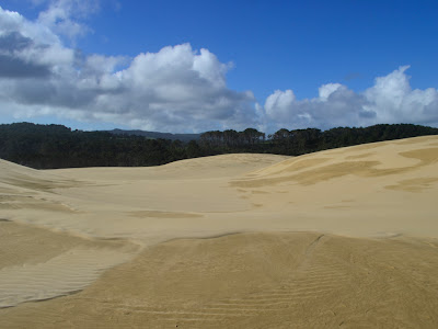
Next stop was the Te Paki Recreation Reserve to see the famous sand dunes. The Te Paki Stream is one of the access points for Ninety Mile Beach, however, if you want to get onto the beach with your car you have to be prepared to drive down the quicksand stream! At approx. 55 miles (88 km) long, from Shipwreck Bay to Cape Maria van Diemen, Ninety Mile Beach is a misnomer. The beach itself is a vast arch of fine white sand, backed by immense dunes and broken by rocky outcrops and shallow streams.
 |
| You have been warned! |
 |
| The Te Paki sand dunes rise up to 140 metres above sea level |
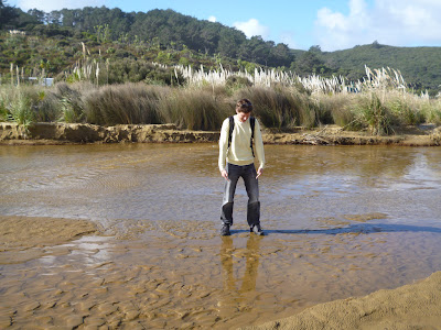
To get over to the sand dunes we had to cross the stream, however I was a little apprehensive about crossing it as the sand was relatively soft and it didn't want to find myself waist deep in quicksand! After plucking up the courage, we reached the base of the massive dunes - however, the next challenge was climbing up them...
 |
| Am I slowly sinking in the sand? Not here but I was elsewhere |
 |
| Lawrence of Arabia eat your heart out! |
Once we got our footing, it felt like we spent ages trekking our way over the endless dunes. It was almost a bit surreal and eerie as it felt like we were in an isolated, arid dessert but without the searing heat.
 |
| The sand dunes are flanked by the Aupōuri Forest
|
We hoped to do some sandboarding down the dunes as we heard it's really fun and cheap, but there wasn't anywhere nearby to hire a board, possibly because we were in the winter season and not as many tourists come up this way. So we made our own fun by running down the dunes instead and rolling to the bottom - although this wasn't as great an idea as we initially thought, as we got sand everywhere in our clothes and hair, as well as places we didn't know you could get sand in!
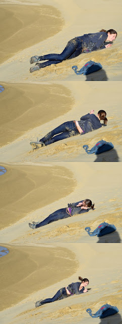 |
| Going, going, gone!
|
 |
| What goes up must come down |
In a stroke of luck we moved on just before some heavy downpours swept in. On the way back we took a detour from State Highway 1F at Pukenui to drive down an unsealed road through a forested area for roughly 10km to where you could gain access to drive on Ninety Mile Beach (Te Oneroa-a-Tōhē or the long beach of Tōhē). However, there was little warning that we were about to join onto the beach... Ninety Mile Beach is classified as a State Highway but is really only suitable for 4WD vehicles or specialist tour coaches. We were too scared to take the car on there as we've read a lot of stories about cars being abandoned on the beach due to them getting stuck in the quicksand. Rentals cars are strictly prohibited from driving on the beach, and private vehicles are not covered by insurance so if you go it alone it can be a big risk. You also need to schedule your trip to coincide with a receding tide, ideally two hours after high tide.

 |
| The flat, endless beach sweeps the horizon towards the Tasman Sea |
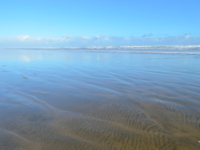
In the end we decided to stick to the more environmentally-friendly method of walking along the beach! Although it was impressive that you couldn't see the end of the beach in either direction, the amount of plastic and rubbish on the beach and in the sand dunes was really disappointing. It was the dirtiest I've ever seen a beach in New Zealand, possibly more so than in Britain, which is a shame for a country that prides itself on being clean.


No comments:
Post a Comment